Best Borehole Log Software for Geotechnical Engineers [2026 Update]
Modern gINT Replacement Options for Smarter, Cloud-Based Logging
Borehole logs remain the foundation of every geotechnical project — from site characterization to final reporting. Yet many firms still rely on gINT, Excel, or PDF templates that can’t keep up with modern project demands.
As Bentley transitions gINT into extended support through 2028, firms are actively searching for modern, cloud-based alternatives that simplify data collection, standardize reporting, and connect field and office teams in real time.
That’s where Aldoa’s new Borehole Logging Software comes in — purpose-built to help geotechnical engineers move faster, eliminate manual entry, and deliver polished reports with less effort.
What Is Borehole Log Software?
Borehole log software allows engineers to record, manage, and visualize subsurface data captured during drilling or sampling. Common inputs include:
- Soil and rock strata
- Sampling intervals and methods
- Groundwater and driller notes
- SPT blow counts and depths
- Field classifications and photos
Traditional workflows in gINT or Excel require manual data transfer and formatting. Modern solutions like Aldoa automate this process — connecting field, lab, and reporting data inside a single cloud workspace.
Why Outdated Tools Like gINT Are Holding Firms Back
gINT has served the industry well, but its desktop architecture and complex templates are showing their age. Engineers cite these common limitations:
- No mobile or cloud access
- Difficult collaboration across offices
- Slow report generation and manual exports
- Steep learning curve for new staff
- Expensive licenses and maintenance costs
As projects scale and clients demand faster turnaround, these friction points directly impact productivity and profitability.
Introducing Aldoa: The Modern Borehole Log Software for Geotechnical Teams
Aldoa is a cloud-native field-to-report platform designed specifically for geotechnical engineering and construction materials testing firms. With Aldoa, you can:
- Log soil data digitally from the field
- Visualize borehole logs instantly in your browser
- Generate engineer-ready reports in one click
- Access and reuse historical logs from any device
- Collaborate across teams and regions in real time
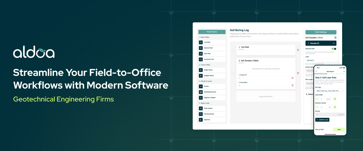
Key Features for Borehole Logging in Aldoa
.png?width=1954&height=1402&name=Group%2027379%20(1).png)
1. Customizable ASTM-Aligned Log Templates
We're working directly with geotechnical engineering firms to build customizable borehole log templates that meet ASTM standards and firm-specific formatting needs.
Key capabilities include:
- Layer-by-layer lithology input
- Auto-calculated drilling depths
- Color-coded strata and material symbols
- Consistent visual outputs in PDF/Word
- Easy integration into full geotechnical reports
This means no more cutting and pasting Excel rows—or toggling between desktop apps and Word templates.
2. GIS Mapping & Enhanced Geolocation Data
Borehole data is only as useful as the context it's tied to. With Aldoa, you can:
- Attach multiple sampling or drilling locations to a single project
- View all boring logs geospatially using Google Maps integration
- Input location data via address or GPS coordinates
- Avoid duplicating project details across files
This is particularly powerful for multi-site investigations, municipal infrastructure projects, or environmental corridor studies, where field data needs to be referenced quickly by location.
3. In-Platform Report Editing (No Exports Needed)
Tired of exporting your borehole data into Word, then manually formatting headers, footers, and tables?
With Aldoa, your borehole logs feed directly into editable PDF or Word reports, so you can:
- Finalize and sign reports within the platform
- Insert boring log visuals alongside lab results and recommendations
- Collaborate on review cycles without version chaos
- Generate client-ready reports in minutes, not hours
4. Cross-Project Dashboards and Data Queries
As your library of borehole data grows, so does the value of being able to query and analyze it at scale.
With Aldoa, you can:
- Build custom dashboards to view borehole info by region, client, or project type
- Run queries across all logs to identify patterns (e.g., clay layers at certain depths)
- Export summaries or visuals for QA/QC or portfolio analysis
- View trends over time to guide future project planning
This transforms borehole logs from static documents into living data assets.
5. Free Form Templating and Fast Onboarding
Unlike older vendors where form changes take months and added fees, Aldoa offers:
- Free form templating (we do it for you)
- Custom log setup included with onboarding
- Most templates deployed in a few days, not months
- A real human on the other end of the line when you need support
We believe that good software should fit your workflow, not force you to change how you work.
Comparing Aldoa vs. gINT and Other Soil Boring Log Software
| Feature |
gINT |
Aldoa (2026) |
| Cloud-based |
❌ Desktop only |
✅ 100% cloud-native |
| Real-time collaboration |
❌ |
✅ Yes |
| Soil boring logs |
✅ |
✅ Yes |
| Google Maps integration |
❌ |
✅ Deep GIS capabilities |
| Cross-project queries |
❌ |
✅ Advanced filters and dashboards |
| Report generation |
⚠️ Manual exports |
✅ Automated reports |
| Pricing transparency |
❌ License + support fees |
✅ Simple, per-user pricing |
| Customer support |
⚠️ Tiered enterprise |
✅ High-touch, responsive |
| eSignature fees |
❌ Additional |
✅ Unlimited, included |
Built for Geotechnical Engineering Firms, Not Generic Use Cases
While some tools focus on general field data collection (like Fulcrum or Survey123), and others are outdated (like gINT), Aldoa is purpose-built for geotechnical workflows, including:
- Subsurface investigation reporting
- Construction materials testing
- Lab-to-field data synchronization
- Regulatory compliance and audits
- Historical data reuse and tracking
Whether you're a small geotech firm or a growing CMT operation, Aldoa scales with your team and helps you spend less time formatting reports—and more time analyzing data.
Frequently Asked Questions about Borehole Log Software
Pricing: No Hidden Fees or Long Sales Cycles
Legacy tools often lock you into:
- Costly per-user licenses
- Extra charges for features like e-signatures
- Implementation fees and long contract terms
With Aldoa, you get:
- Lower per-user pricing
- Unlimited eSignatures at no extra cost
- No surprise add-ons
- Free templating, fast onboarding, and a product team that listens
Conclusion: The Future of Borehole Logging Is Cloud-Based, Collaborative, and Cost-Effective
If you're still managing soil boring logs in Excel, gINT, or legacy software, now is the time to upgrade to a modern, cloud-based platform.
Aldoa offers everything geotechnical engineering teams need to manage field data, visualize borehole logs, generate professional reports, and collaborate more efficiently—without the high cost or complexity.
Ready to Streamline Your Borehole Logging Process?
Book a demo with Aldoa and see how we're helping firms move faster, reduce manual work, and deliver better reports—with a platform built for geotechnical professionals, not generic data collectors.
.svg "Aldoa Assets (3)")