Geotechnical | Materials Testing | Environmental

Digital Site Maps for Geotechnical & CMT Projects

Aldoa’s Digital Site Map replaces paper maps and disconnected tools with a cloud-based mapping interface purpose-built for field testing and sampling. Whether you're performing compaction tests, concrete pours, or soil borings, every location, photo, and form stays connected—and easy to find.

Digital Site Maps

Key Features That Set Aldoa Apart

Trusted by 100+ Firms in over 30 States. Rated 4.8 out of 5 Stars on Capterra.

Map + List Views

View your projects through our Google Maps API or on a simple list view to stay organized and in control. Aldoa's multiple project views make it easy to coordinate field activities, monitor progress, query historical sampling data, and ensure full coverage across every job site.

Upload and Layer Site Plans

Bring your site plans to life by uploading PDFs or image files and layering key information directly on top. Add annotations, highlight sampling zones, and overlay utility lines or structures to give field teams the context they need to work accurately and efficiently.

Geolocation-Linked Pins

Drop pins on a digital site plan or map using GPS coordinates or manual placement—instantly linking each location to relevant data, tasks, or observations. Make it easy to track where samples were collected, identify data gaps, and visualize your work back at the office.

Instant Form Access

Click on any pin or mapped location to open the associated form instantly—no digging through folders or spreadsheets. With Aldoa, technicians can record, review, or update data entries directly from the map, streamlining workflows and reducing the risk of missed or misplaced information.

On-Site Visualization—Built for Technical Field Work

Turn your site plan into a live map where field data, annotations, and test locations come together in one place.

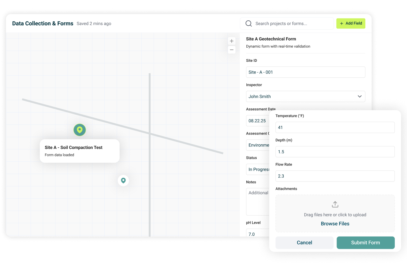
Map-Based Project View

Get a real-time, visual overview of every test on your site. Aldoa’s interactive map makes it easy to track fieldwork, monitor progress, and quickly find the data you need—all in one centralized view.

  • Pin and categorize test locations on multi-layered, interactive site maps.
  • Toggle between map and list views to track work efficiently. Filter by test type, technician, date, status, and more.
  • Avoid data loss with a searchable, centralized site history.
Integrated Data and Forms

Integrated Data & Forms

Seamlessly connect your field data to exact test locations. With every pin linked to forms, notes, and photos, Aldoa keeps your data organized, accessible, and always in sync across the platform.

  • Tap any location to view linked field forms, notes, and photos.
  • Syncs directly with Field Data Collection, LIMS, and Reporting.
  • Update data live from the field—no re-entry required.

Smart Site Plan Tools

Turn static PDFs into dynamic, digital site plans. Aldoa lets you annotate, customize, and interact with your site plans—so your team can collaborate more effectively and stay aligned as work evolves.

  • Upload multi-page PDF site plans directly into the platform.
  • Drop pins and add detailed location notes (e.g., test type, depth, tech).
  • Draw, annotate, and add comments or flags directly onto the plan.
Digital Site Maps

Trusted by 100+ organizations

Ready to Move Beyond Paper?

Aldoa's Digital Site Map makes every test, pin, and plan work smarter—for the field, the lab, and the client. Request a personalized demo and discover how the digital site map helps your team:

  • Eliminate paper-based confusion.
  • Track testing with pinpoint accuracy.
  • Connect location data to forms, reports, and QA workflows.
“In just a few months, Aldoa has done more for us than other software providers did in a year. Their responsiveness and trunaround times have been excellent.”
Thia Light, Project Engineer
Maakil Group

Get a personalized demo of Aldoa
After you fill out this form, you will be able to schedule time directly

Modern Software for Geotechnical and Materials Testing Firms